Groundwork Milwaukee Connects the Dots on Flood Risk, Climate Change, and Public Health
Many Wisconsinites are familiar with the fact that Milwaukee ranks as one of the most segregated cities in the United States. This unfortunate status is no accident, but a result of historical government housing policy from the 1930’s. The goal of the policy was to slow down the rate of foreclosures that ran rampant in the years following the Depression. In this interview with the Wisconsin Environmental Health Network,
Young Kim explained how Groundwork Milwaukee crews were setting their sights on the very real and urgent matter of building resilient communities that can stand up to the effects of climate change, flooding in particular at the beginning of the season.

The Link Between Racist Housing Policies of the Past and the Climate Risks of Today
Yale Climate Connections, March 18th, 2021
Groundwork USA, a network of environmental justice organizations, is exploring the connection between formerly redlined neighborhoods and the climate crisis today. As part of its Climate Safe Neighborhoods initiative, Groundwork overlaid historic redlining maps from nine U.S. cities with data about tree cover, heat, and impervious surfaces such as asphalt and concrete. All of the maps discussed in this interview were made by Groundwork Milwaukee. View full story.
Yale Climate Connections, March 18th, 2021
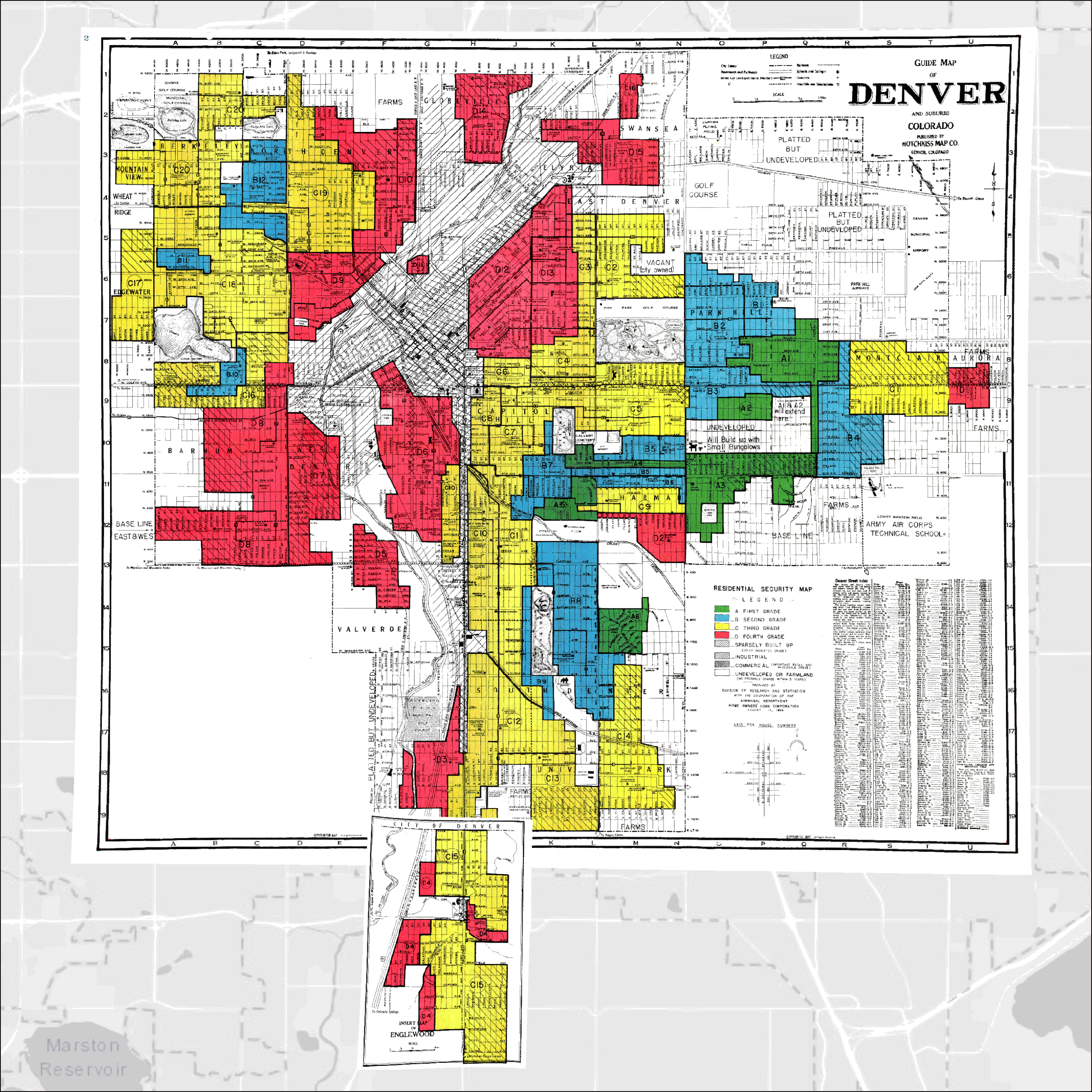
Maps of Denver show neighborhoods, outlined in red, that were once redlined. Today, such neighborhoods often have fewer trees and experience hotter temperatures in summer than other neighborhoods nearby. (Images credit: Groundwork Milwaukee)
Groundwork USA, a network of environmental justice organizations, is exploring the connection between formerly redlined neighborhoods and the climate crisis today. As part of its Climate Safe Neighborhoods initiative, Groundwork overlaid historic redlining maps from nine U.S. cities with data about tree cover, heat, and impervious surfaces such as asphalt and concrete. All of the maps discussed in this interview were made by Groundwork Milwaukee.


Mapping Project Explores Links Between Historic Redlining and Future Climate Vulnerability
WBUR-Boston, March 6th, 2021
This story on Boston’s local NPR station, WBUR discusses Groundwork USA’s Climate Safe Neighborhoods efforts in the Lawrence, MA area. All of the maps discussed in this story were made by Groundwork Milwaukee! Learn more about Climate Safe Neighborhoods below. View full story.
WBUR-Boston, March 6th, 2021

A map animation comparing historical redlining boundaries to current landcover and surface temperature in Haverhill, MA. Groundwork Milwaukee has made maps similar to these for nine cities. In each instance their is a strong relationship between historical practices of segregation and current vulnerability to climate change.
This story on Boston’s local NPR station, WBUR discusses Groundwork USA’s Climate Safe Neighborhoods efforts in the Lawrence, MA area. All of the maps discussed in this story were made by Groundwork Milwaukee! Learn more about Climate Safe Neighborhoods below.
